Posted on

1/24/2012 — MSM headline — Tokyo HIGH (large) QUAKE probability = 70-98% chance

watch the video report here:

——————————————————


Full story here:

http://www.cnn.com/2012/01/24/world/asia/tokyo-quake-forecast/index.html?hpt=hp_t3

Tokyo sees high quake probability, scientists warn
By Elizabeth Yuan, CNN
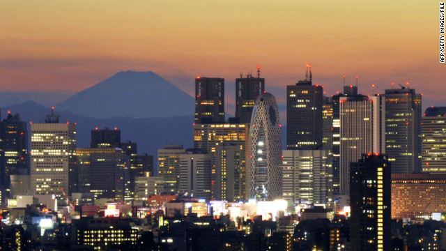
Japan's highest mountain, Mount Fuji, rises behind Tokyo's skyscraper skyline, as the sun sets in this photo last year.
“Japan’s highest mountain, Mount Fuji, rises behind Tokyo’s skyscraper skyline, as the sun sets in this photo last year.
STORY HIGHLIGHTS
  • Forty-two million people live in Tokyo metropolitan area
  • University researchers cited findings on increase in small tremors
  • Government put 70% probability of magnitude-7 quake in region within 30 years
  • March 11 quake and tsunami left more than 15,700 dead, government says

(CNN) — Tokyo faces the possibility of being hit by a massive earthquake within the next four years, according to Japanese researchers.

The University of Tokyo’s Earthquake Research Institute predicts there is a 70% probability that the capital’s metropolitan area will experience a magnitude-7 quake within four years and a 98% probability within the next 30 years.

Nearly one year ago, a magnitude 9.0 quake struck off Japan’s central Pacific coast, triggering a devastating tsunami and aftershocks that left more than 15,700 dead, according to a government report in December on Japan’s recovery from the catastrophe. About 4,500 were listed as missing.

Nearly 700 aftershocks registering magnitude 5 or greater followed last year’s quake, the government report said.

The March 11 earthquake — dubbed “Tohoku” after the region in which it occurred — also damaged the Fukushima Dai-ichi nuclear power station, where three reactors experienced full meltdowns, creating a nuclear crisis for a country already grappling with disaster.

Quake, tsunami debris threaten coastlines

The research institute cited for its findings the Gutenberg Richter Law, which states that an increase in small tremors will likely increase the number of larger earthquakes. According to another paper published in September, the institute concluded that the quake ruptured a fault area nearly 500 kilometers in length and 200 kilometers wide offshore.

The fourth strongest quake recorded in history, Tohoku caused abrupt stress changes in the upper plate and triggered widespread seismic activity throughout the Japanese island. The northern part of Ibaraki Prefecture, in particular, saw a significant increase of shallow seismicity after the quake compared with the extremely low rate eight years prior, the researchers said.

Should Tokyo’s inhabitants be worried?

The research institute’s findings carry great consequences for the 42 million people who live in the Tokyo metropolitan area. The Central Disaster Management Council has estimated that a large-scale earthquake in the next few decades could result in 11,000 deaths and an economic loss of 112 trillion yen (US$1 trillion). Its goal is to halve the estimated death toll and reduce the estimated economic loss.

How precise are seismic forecasts?

Gary Gibson, a seismologist at Australia’s Seismology Research Centre Seismology Research Centre, called the Earthquake Research Institute’s findings “not at all unexpected,” given the level of seismic activity and their model.

“Seismologists cannot predict with certainty when, where and how large the next big earthquake will be,” he wrote in an e-mail to CNN. “However, it is possible to forecast the probability of an earthquake in a particular time range (e.g. the next four years), location area (e.g. the Tokyo region), and magnitude range (e.g. greater than magnitude 7.0).

“Long-term forecasts use average activity levels from past earthquakes, geological data from fault displacements, and data about plate movement and deformation from very precise GPS measurements and other methods to determine these probabilities.”

What is the government saying?

The government’s Headquarters for Earthquake Research Promotion had put a 70% probability of a magnitude-7 quake in Kanto region, which encompasses Tokyo and Yokohama, within 30 years, based on long-term seismicity and hazard studies.

Scientists have already dubbed as “Tokai” an expected 8.0 quake near Suruga Bay, where large quakes have historically struck every 100-150 years, according to the Japan Meteorological Agency. The last one, a magnitude-8.4 quake, occurred in 1854 — nearly 160 years ago.

According to Gibson, the seismologist, the enhanced seismicity in the area affected by the Tohoku quake may fall towards normal levels and could affect the research institute’s findings. Results for the six-month period after the quake would become available after this coming March 11…. (read whole article at link above)

Posted on

1/23/2012 — 6.3 magnitude earthquake north of New Zealand = Pacific plate unrest

watch the video update here:

—————————————————

Another sizable earthquake has occurred around the Pacific ring of fire — this time it has struck north of New Zealand — south of the Fiji islands: (1/24/2012 1252pm NZ time):


here is a screenshot of ONE WEEK of 6.0M+ earthquakes around the Pacific — shows a fair amount of movement :

See the previous posts from today:

6.2M in chile :

http://sincedutch.wordpress.com/2012/01/23/1232012-6-2-magnitude-earthquake-in-chile-movement-picking-up-in-intesity/

5.1M in Dominican Republic:

http://sincedutch.wordpress.com/2012/01/23/1232012-5-1-magnitude-earthquake-in-dominican-republic-uptick-continues/

5.0M in Hawaii (and swarm afterwards):

http://sincedutch.wordpress.com/2012/01/23/1222012-big-island-hawaii-5-0-magnitude-4-1m-back-to-back-followed-by-earthquake-swarm-puu-oo-volcano/

—————————————————-

Here are the stats on the most recent quake:

Magnitude 6.3 – SOUTH OF THE FIJI ISLANDS

2012 January 24 00:52:06 UTC

Versión en Español

Earthquake Details

  • This event has been reviewed by a seismologist.
Magnitude 6.3
Date-Time
  • Tuesday, January 24, 2012 at 00:52:06 UTC
  • Tuesday, January 24, 2012 at 12:52:06 PM at epicenter
Location 24.959°S, 178.611°E
Depth 582.8 km (362.2 miles)
Region SOUTH OF THE FIJI ISLANDS
Distances 543 km (337 miles) SE of Ceva-i-Ra, Fiji
551 km (342 miles) SSW of Ndoi Island, Fiji
756 km (469 miles) S of SUVA, Viti Levu, Fiji
1370 km (851 miles) NNE of Auckland, New Zealand

here is the link to the official statistic page from the USGS for this earthquake:

http://earthquake.usgs.gov/earthquakes/recenteqsww/Quakes/usc0007qr4.php

=================================

Here are several links to monitor the earthquakes in your particular area:

:

http://sincedutch.wordpress.com/2011/11/30/11302011-list-of-earthquake-links-for-global-monitoring/

Link to DOZENS of Volcano webcams:

http://sincedutch.wordpress.com/2012/01/02/112012-all-the-volcano-webcams-of-the-world/

Volcano webcams:Yellowstone park geyser webcams: http://www.nps.gov/yell/photosmultimedia/webcams.htm

Japanese Mount Fuji Webcams:

http://www.goandroam.com/webcams/japan/mt_fuji

http://www.fujigoko.tv/live/shotList.cgi

Japanese Sakurajima Volcano webcams: http://webcam-svo2.pr.kyoto-u.ac.jp/local/camera.html 

Sakurajima official youtube page: http://www.youtube.com/cubhf137

Cascades Pacific Northwest webcams: http://www.skimountaineer.com/CascadeSki/CascadeWebCams.php?weather=true

Mount St. Helens webcams: http://www.fs.fed.us/gpnf/volcanocams/msh/

All the known volcano webcams of the world (Italy, Russia, Iceland, South/Central America, Spain and several other locations) : http://bigthink.com/ideas/26619

==========================================================

United States earthquake sources:

List of US  seismographs : http://www.ceri.memphis.edu/seismic/heli/index.html

Arkansas seismic network: http://www.geology.ar.gov/geohazards/ark_seismic_network.htm

map of New Madrid Seismic Zone seismograph locations (interactive): http://www.ceri.memphis.edu/seismic/stations/nmsz.html

Midwest USA seismographs:

http://folkworm.ceri.memphis.edu/heli/heli_sp_mkta/

http://folkworm.ceri.memphis.edu/heli_bb_slu/

http://folkworm.ceri.memphis.edu/heli/heli_sp_nmad/

http://folkworm.ceri.memphis.edu/heli/heli_sp_athn/

http://folkworm.ceri.memphis.edu/heli/heli_sp_lnxt/

http://folkworm.ceri.memphis.edu/heli/heli_sp_mttn/

http://folkworm.ceri.memphis.edu/heli/heli_sp_ceri/

http://folkworm.ceri.memphis.edu/heli/heli_uky/

USGS netquakes site live :

http://earthquake.usgs.gov/monitoring/netquakes/

http://earthquake.usgs.gov/monitoring/netquakes/map/

New Madrid seismic zone (NMSZ information): http://www.showme.net/~fkeller/quake/maps.htm

Pacific Northwest Seismic Network :

http://www.pnsn.org/WEBICORDER/BETTER/pnsn_staweb/index.html

http://www.pnsn.org/OPS/stations.html

Official USGS earthquake site: http://earthquake.usgs.gov/

USGS live internet seismic server: http://aslwww.cr.usgs.gov/Seismic_Data/heli2.shtml

USGS full index of seismographs : http://aslwww.cr.usgs.gov/Seismic_Data/telemetry_data/

California seismographs:

http://pasadena.wr.usgs.gov/webicorder/

http://earthquake.usgs.gov/monitoring/helicorders/nca/

USGS ANSS seismograph backbone:

http://earthquake.usgs.gov/monitoring/anss/

http://aslwww.cr.usgs.gov/Seismic_Data/telemetry_data/map_sta_eq.shtml

USGS weekly volcanism report: http://www.volcano.si.edu/reports/usgs/

USGS Hawaii data clearinghouse: http://hawaii.wr.usgs.gov/

USGS Hawaii earthquakes : http://tux.wr.usgs.gov/

Alaska Volcano observatory: http://www.avo.alaska.edu/

Mount Baker (pacific northwest): http://mbvrc.wwu.edu/index.shtml

West Coast / Alaska Tsunami warning center: http://wcatwc.arh.noaa.gov/events/eventmap.php

Pacific Tsunami Warning center: http://ptwc.weather.gov/

National Data Buoy Center (monitor buoys for wave activity): http://www.ndbc.noaa.gov/

Pacific  Basin Information node: http://www.nbii.gov/portal/server.pt?open=512&objID=240&mode=2&in_hi_userid=2&cached=true

East coast (columbia college) seismographs: http://www.ldeo.columbia.edu/cgi-bin/LCSN/WebSeis/24hr_heli.pl?id=

Yellowstone supervolcano seismographs: http://www.isthisthingon.org/Yellowstone/daythumbs.php

Montana .edu / yellowstone seismographs: http://mbmgquake.mtech.edu/earthworm/wavef_disp/current/welcome.html

University of Utah yellowstone seismographs: http://www.quake.utah.edu/helicorder/

====================================================================

Rest of the world (always updating with more):

Mexico seismographs: http://www.ssn.unam.mx/

Belgium seismographs: http://seismologie.oma.be/index.php?LANG=NL&LEVEL=210

Philippines earthquakes and volcanic activity: http://www.phivolcs.dost.gov.ph/

Swiss seismology: http://www.seismo.ethz.ch/index

Canadian seismographs:

http://earthquakescanada.nrcan.gc.ca/recent/index-eng.php

http://earthquakescanada.nrcan.gc.ca/stndon/wf-fo/trace_app.php?target=MNTQ.BHZ

http://earthquakescanada.nrcan.gc.ca/recent/maps-cartes/index-eng.php

http://www.ggl.ulaval.ca/

Russian seismographs: http://www.ceme.gsras.ru/ccd.htm

Japanese seismographs: http://www.gsi.go.jp/ENGLISH/index.html

Thailand seismicity / seismographs : http://www.seismology.tmd.go.th/en/index.php

Australian seismographs:

http://www.seis.com.au/

http://www.ga.gov.au/earthquakes/

Netherlands seismographs: http://www.knmi.nl/seismologie/aardbevingen-nederland.html

New Zealand seismographs: http://quake.crowe.co.nz/Mobile/

Iceland seismographs: http://en.vedur.is/earthquakes-and-volcanism/earthquakes/

England / UK seismographs: http://www.earthquakes.bgs.ac.uk/helicorder/heli.html

Italy seismographs: http://cnt.rm.ingv.it

Taiwain  earthquake information: http://www.cwb.gov.tw/V6e/index.htm

EMSC European Mediterranean earthquake agency map/index :

http://www.emsc-csem.org/Earthquake/Map/jsmap.php?key=1&typ=world

http://www.emsc-csem.org/Earthquake/index.php

http://www.emsc-csem.org/Earthquake/Map/index.php

Spanish (El Hierro Canary islands) seismographs: http://www.01.ign.es/ign/head/volcaSenalesAnterioresDia.do?nombreFichero=CHIE_2011-11-03&ver=s&estacion=CHIE&Anio=2011&Mes=11&Dia=03&tipo=2

Indonesia seismographs: http://aeic.bmg.go.id/

=======================================================

Global links for earthquake monitoring:

Monitor earths rotation: http://hpiers.obspm.fr/ 

COSMOS earthquake data global list: http://db.cosmos-eq.org/scripts/earthquakes.plx

Download the free version of earthquake3D: http://download.cnet.com/Earthquake-3D/3000-2054_4-10395116.html

Global IRIS earthquake browser: http://www.iris.edu/servlet/eventserver/map.do

Global earthquake mashup of EMSC, USGS, GFZ : http://www.oe-files.de/gmaps/eqmashup.html

Topographic maps of the USA and Canada: http://www.topozone.com/

intellicast (turn on earthquake view): http://www.intellicast.com/Local/WxMapFull.aspx

Global Incident Map: http://www.globalincidentmap.com/

RSOE EDIS global incident map : http://hisz.rsoe.hu/alertmap/